 |
| Royal Tern |
I remember going on vacations before the GPS. We got a Trip-Tick from AAA, and read the maps from the top of the page to the bottom, no matter what direction we actually drove. Or we used those huge fold up maps that never folded back as smoothly as they were before we opened them. And they never had enough detail to guide you through a city without looking for the inset on the other side altogether. ACK! What frustration!
 |
| Brown-headed Nuthatch |
God bless the GPS! Today we actually went birding, guided by the North Carolina Birding Trail Guide. Many states publish books directing birders to various birding hotspots within the state. Studies show that birders spend lots of money traveling just to see someone else's birds. We like the guides for Florida and Texas, but Alabama's is pretty complicated. The Alabama book leads you from one point to another, but if you want to jump over one to reach the next, you still have to follow the map and figure out how to reach point C from point A. Of course, many birding spots are out in the middle of nowhere, and words fail to lead you to the destination when there aren't any street signs to be seen in the first place.
 |
| Pine savanna after controlled burn |
Once we figured out which section in the North Carolina book actually applied to the southeastern coast, there were many opportunities to choose from. Each page showed a small map, had written directions and enticed us with the birds we might find there. Most importantly, they had the latitude and longitude for each site. Our first stop was the Green Swamp Preserve, owned by the Nature Conservancy, and located on "NC211, 5.7 miles north of Supply, NC." Well, that certainly is clear enough for an out-of-towner...NOT!
 |
| Pine Warbler |
We discovered that you don't have to know a street address for the GPS (which we fondly call Gabby). The latitude and longitude coordinates can go into it, and she then gives driving directions. Today, Gabby even warned us that we were going "off road" when we reached the barely marked turn off to the Conservancy property. This site is known for its longleaf pine savannas, and we walked for a mile or so, looking for the Red-Cockaded Woodpeckers which can be found there. Unfortunately, the Nature Conservancy didn't mark the woodpecker trees as Florida Fish and Game people did, so we didn't see any woodpecker. We did find some terrific Brown-headed Nuthatches and Pine Warblers, as advertised. The Conservancy had made controlled burns on the savanna, and we walked through one which was fairly recent, into another area where the grass was thriving, and another full of brush and needing a burn before long.
 |
| Ruddy Turnstone |
Delighted by our success, we asked Gabby to take us to the Southport Riverwalk where we might see White Ibis, Glossy Ibis, Seaside Sparrows or Painted Buntings at the salt marsh, maritime forest and shrub or beach. Sounds wonderful, doesn't it? Along the way we passed a small country general store, which advertised "Worms and Coffee." Something for everyone!
 |
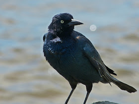
| Grackle |
Apparently, this description was written by someone from the Chamber of Commerce who isn't really a birder. The "boardwalk" was no longer than 20 yards along the side of the Cape Fear River in the town of Southport, NC. A few juvenile gulls and some Ruddy Turnstones sat on the sea wall, scolded by huge Grackles. We saw no salt marsh or maritime forest at all, while the "beach" was 5 feet wide at low tide. Yes, we are such good birders, we timed our marsh birding for the low tide of the day!
 |
| Mudflats at low tide |
All right, let's give it one more try. Sunset Beach Island is a barrier island, with salt marsh, maritime shrubs, beach and dunes. Sounds good, and it's now low tide. Crossing the causeway, we saw miles of marsh. Yeah, this is going to be good! But like many barrier islands, there seemed to be more houses than bird habitat, and people don't want you walking through their minuscule yards for a better view of what habitat there is.
 |
| For Sale |
At one end of the small island, the road stopped at a gate and a sign advertising lots for sale - marked down from $1,100,000 to a mere $869,000, and that's just for the LOT! Dick was surprised when his law abiding wife said, let's walk down the fence and see if we can get in anyway, since this is the best way to see the marshes.
 |
| Pelicans dancing |
Spotting scope in hand, we worked down to the exposed sand and had a wonderful time watching the gulls, terns, pelicans, oyster catchers and black skimmers on the sand bars. It felt like we walked at least a mile, but my 24X zoom lens still couldn't bring the birds in close enough to suit me. I tried using the small camera for some digiscoping, and only got a photo of the inside of the scope!
 |
| Undeveloped Dunes |
I always get irritated when people spend big wads of money to build houses on the sand. Houses that will eventually get flooded or blown away. My insurance rates reflect the losses all the insurance companies pay for people with no sense and no respect for nature. Don't get me started on federal flood insurance for these idiots! But the GPS - now that's a terrific tool for birding!


Denapple, you are just too funny! Love the pics and the story and I agree with you about the houses built on the sand!
ReplyDelete